

Innovation and Collaboration with NCDOT Earn Accolades
/Project ATLAS Uses Geospatial Technology to Deliver Significant Public Benefits
GeoDecisions’ close collaboration with the North Carolina Department of Transportation (NCDOT) has resulted in international recognition for the agency’s outstanding achievement in the use of geospatial technology. The Urban and Regional Information Systems Association (URISA) honored NCDOT’s Project ATLAS with a 2021 Exemplary Systems in Government (ESIG) award. Project ATLAS, which offers a suite of GIS applications and data, won a Distinguished System award in the Enterprise Systems category.
GeoDecisions was a key partner in the design, development, deployment, and user training for Project ATLAS, working hand in hand with the North Carolina Department of Information Technology-Transportation (NCDIT-T) and DOT business experts to deliver the system. ATLAS enables NCDOT to streamline transportation project development using GIS data and applications.
“ATLAS stands for Advancing Transportation through Linkages, Automation, and Screening,” noted LeiLani Paugh, NCDOT’s ATLAS project manager. “As the acronym suggests, the objectives were to create linkages across data silos and systems; to increase efficiency by automating project data, document storage, and program analysis; and to inform scopes, schedules, and budgets through GIS screening of project characteristics and effects.”
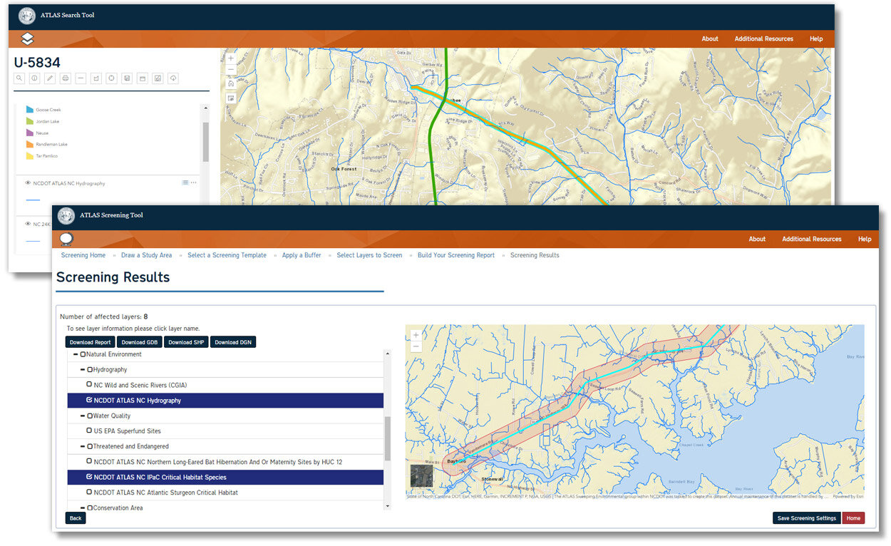
Project ATLAS compiles more than 600 GIS layers and provides four web applications for DOT staff, consultants, and external partners. Its Search Tool is a one-stop shop for project development-related GIS data. The Screening Tool allows users to evaluate project study areas. The ATLAS Workbench captures key project information and provides a user-friendly web map. The ATLAS Admin Tool allows for the easy administration of ArcGIS Portal users and groups by NCDOT business owners and enables subject matter experts to update and maintain more than 800 GIS web services and associated metadata.
Since its implementation, ATLAS has decreased the fieldwork required to obtain environmental permits on time for grant-funded broadband transportation projects and improved spatial data quality and availability on behalf of agencies outside of NCDOT. It has also helped identify new technologies and ideas to support NCDOT business units and divisions.
“ATLAS is exemplary,” Paugh said, “because it paired DOT business experts with GIS and IT technical professionals to design a robust suite of GIS enterprise applications and data to support NCDOT operations and business intelligence for years into the future.”
Each year, the URISA ESIG awards program recognizes the effective application of geospatial technologies and data that result in improved government service delivery and increased benefits to citizens. The international competition is open to all public agencies at the local, regional, state/provincial, and federal levels.


