
Leveraging Data for Strategic Project Prioritization
/
In this fourth and final installment of an IIJA grant management solutions blog series, learn how technology increases agency efficiency, leverages geospatial data points for better decision-making, and supports fiscal responsibility. Leveraging data with technology can help transportation agencies get the most from the historic Infrastructure Investment and Jobs Act funding.
Reference the first, second, and third installments for more on grant management.

If we think about our work capacity like our holiday dinner plates, we already have the mashed potatoes, carrots, turkey, and ham – but we don’t have room to add Aunt Martha’s jello salad.
Do more with less. Most people cringe when they hear this phrase. Especially because most people’s work plates are already full.
Transportation agencies are often asked to do more with less (or do more with the same) as they balance the organization’s goals and stakeholder expectations with the realities of staffing, funding, supply chains, and other constraints.
The good news is that Infrastructure Investment and Jobs Act (IIJA) will allow transportation programs to receive more funding available through a multitude of available grants.
However, IIJA has not solved every challenge that large, complex transportation organizations face. Smart investment and innovations remain critical to move these agencies and the communities they support forward. Departments of transportation have large backlogs of needs and will benefit from finding efficiencies in the way they operate to best handle the anticipated increased funding and project implementation workload to achieve their goals.
They also will benefit from using tools to help decide which projects to pull off the shelf when they apply for and receive new grant dollars into their financial systems.
Innovative web-based applications can help transportation organizations continue to achieve organizational goals while meeting stakeholder expectations.
Innovations can play an important role in solving these challenges and often come in the form of business process improvements and technology tools that:
Add, implement, or create process efficiencies.
Eliminate duplicative efforts and manual processes.
Mitigate risk by eliminating opportunities for human error.
Creating decision support tools and prioritization processes can help these transportation agencies to smartly invest their limited resources in projects that will have the most impact and return on their investment.
Improvements such as connecting the data from one department to another can result in significant cost savings and even save lives.
GeoDecisions, a division of Gannett Fleming, partners with our clients to bring innovative solutions and implement resolutions from lessons learned on past projects into future grant-funded projects and programs. The following examples highlight how GeoDecisions has helped our clients achieve their short- and long-term goals through various grant programs.
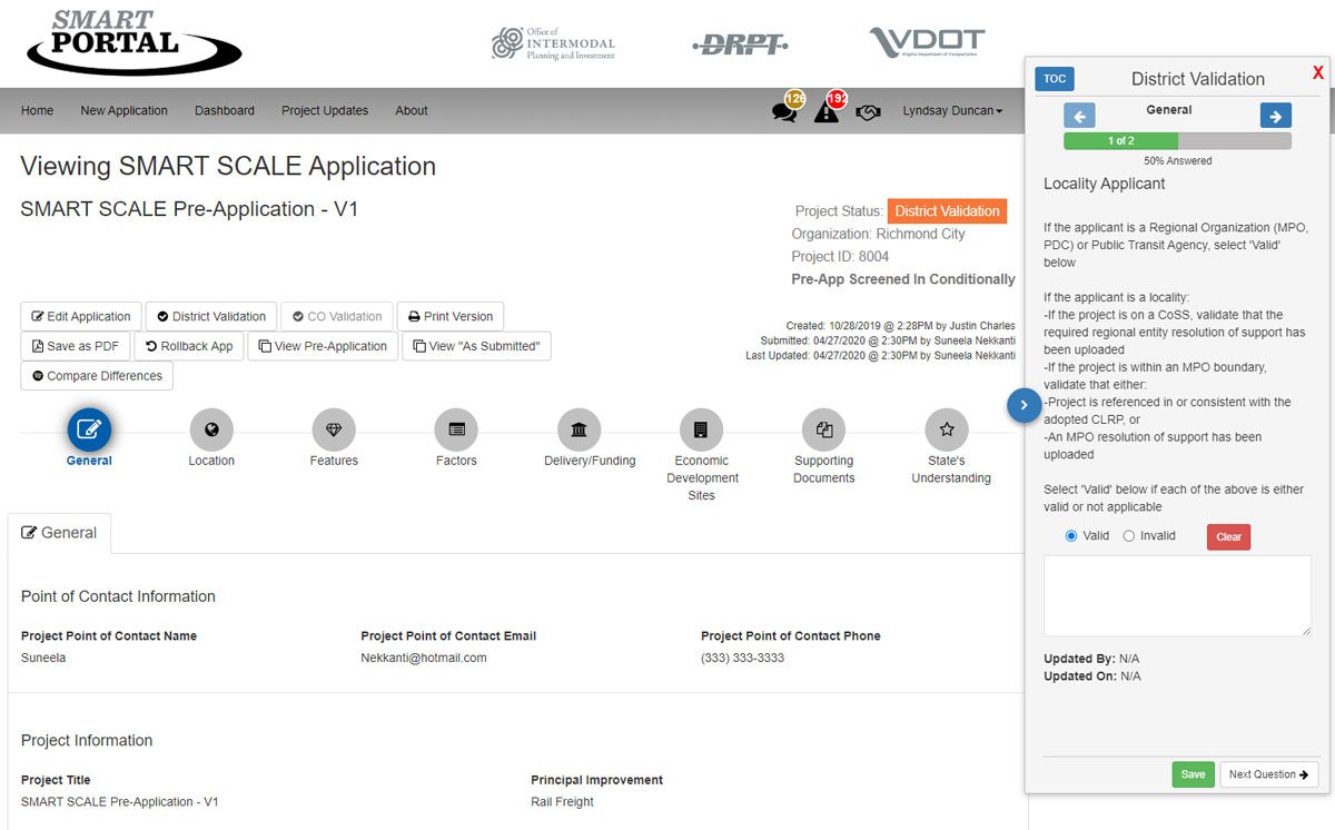
The enhanced SMART Portal improves the grant application validation process.
Client: Virginia Department of Transportation (VDOT)
Project: SMART Portal Application
Purpose: VDOT needed to improve its existing web-based application tool to facilitate the intake, validation, and scoring of a constantly increasing number of applications for multiple project prioritization-based grant programs.
The agency also needed a process to help applicants submit complete applications that are eligible for funding, and re-submit applications not funded in prior cycles.
How GeoDecisions helped VDOT:
Developed a grant management software application to help VDOT manage their transportation funding.
Saved time by automating receipt, validation, and scoring of grant applications for multiple grant programs.
Mitigated grant projects risk by improving communication between VDOT and grant applicants.
Improved efficiencies within VDOT to process the numerous grant applications.
Created processes to help VDOT track the various project requirements.
The tool allows VDOT to maintain previously submitted data so that it is available for resubmission, if appropriate, and enables editing of loaded data. Additionally, it allows applicants to submit for multiple grant programs through a single web-based portal, simplifying the application process and enhancing the user experience.
GeoDecisions developed an administrative toolset to help VDOT better manage the SMART Portal system, users, and organizations through user interface controls. Enhancements to the comments module:
Improved communication between VDOT review staff and applicants.
Allowed VDOT to validate the information to improve the quality of submitted applications.
Additional scoring tools allow VDOT to select the best projects to gain the most from their grant opportunities and financial investment.
The resulting application allows stakeholder groups to define and test planning scenarios determining the optimal facilities investment strategies.
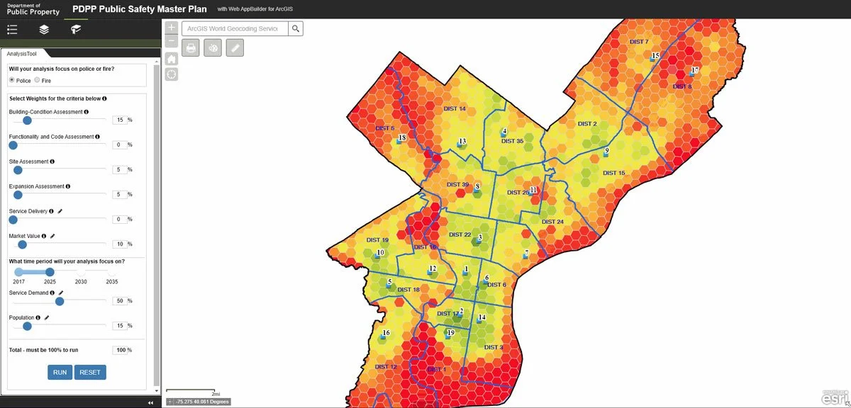
Client: City of Philadelphia
Project: City of Philadelphia Department of Public Property (DPP) Decision Support Tool
Purpose: The City of Philadelphia DPP is responsible for allocating their limited investment funds across all of the city departments, including the Philadelphia Police and Fire Departments. The city has more than 100 facilities, which all have their individual needs, maintenance requirements, and project requests. DPP needed help with project prioritization based on multiple factors, including urgency.
“We were looking for a way to guide our decision-making process for capital projects. The GIS-based decision support tool developed by GeoDecisions makes it simple and extremely quick to factor in millions of data points and guide investment choice.”
How GeoDecisions helped the City of Philadelphia:
Implemented geospatial principles to create decision model.
Saved time by bringing key information together to support smart investment decisions through data analytics.
Increased return on investment by allocating funds to the facilities with the most need.
Designed predictive analytics tools to allow the city to forecast demand through 2035.

The crop rotation feature gives planners a list of identifiers to help them make crucial decisions.
Purpose: Similar to how DOTs need to prioritize projects, departments of conservations/environmental protection and farmland operators need to prioritize the ideal soils that will help achieve the farm’s greatest return on investment and have the least environmental impact.
VA DCR needed an improved technology solution, which ultimately resulted in the ideal soil selection for each operator’s farmland. The solution needed to:
Be complete with Esri ArcGIS Desktop tools.
Increase web mapping functionality.
Have the ability to automate data analysis.
How GeoDecisions helped VA DCR:
Saved time by automating soil selection.
Created efficiencies by evolving away from manual data integration within the Conservation Application Suite.
Developed better data visualizations.
Improved operational awareness.
Reduce soil runoff deterrence.
Increased overall efficiency.
The greatest improvement to VA DCR’s system was the ability for planners to standardize the soil selection process, just as DOTs benefit from a standardized process to prioritize projects to align with various grant programs. With the previous application:
Data was stagnant because each individual data aspect had to be manually input, meaning updates had to be hard coded versus being updated automatically.
Field soils were manually selected, increasing the possibility for user error and/or miscalculation or misinterpretation.
Did not have mapping capabilities – all mapping was done separately, resulting in a longer visualization process which increased budget requirements and decreased efficiency.
With the AgBMP Tracking Module, all soil selection is done spatially through automation, increasing the planning accuracy, and saving stakeholders time and resources.
Summary: Data-Driven Decision Making
These projects are just a few examples of how technology can save organizations time and money and support them in achieving their business goals. GeoDecisions welcomes the opportunity to brainstorm with transportation leaders across the country about how to get the most out of the historic IIJA funding to make your communities and infrastructure stronger well into the future.
Email Bryan Kelley, PMP, senior project manager, to learn more about how we can help you create a custom solution for your IIJA grant management needs.
About the Author

Bryan Kelley, PMP
Senior Project Manager
Email Bryan
Connect on LinkedIn
Get to Know Bryan


