
Using Geospatial and Planning Technology to Improve Operations at the Virginia Department of Conservation and Recreation
/Client: Virginia Department of Conservation and Recreation
Location: Virginia
CHALLENGE
The Virginia Department of Conservation and Recreation (VA DCR) is responsible for helping farmland operators with their nutrient management, guaranteeing the correct amount of nutrients for crop production, and reducing the incidents of harmful soil runoff. Before working with GeoDecisions, VA DCR’s management application was downloaded onto each planner’s computer, translating into all improvements and updates being hard coded into the application. To improve VA DCR’s Agriculture Best Management Practices (AgBMP) Conservation Application Suite, they needed an improved technology solution complete with ArcGIS Desktop tools, increased web mapping functionality, and the ability to automate data analysis, ultimately resulting in the ideal soil selection for each operator’s farmland.
The previous application required extensive custom web development, which was cost-prohibitive. In addition to creating desktop tools, GeoDecisions also improved the spatial operations within the web mapping application, helping planners develop high-quality data visualizations for their stakeholders.
SOLUTION
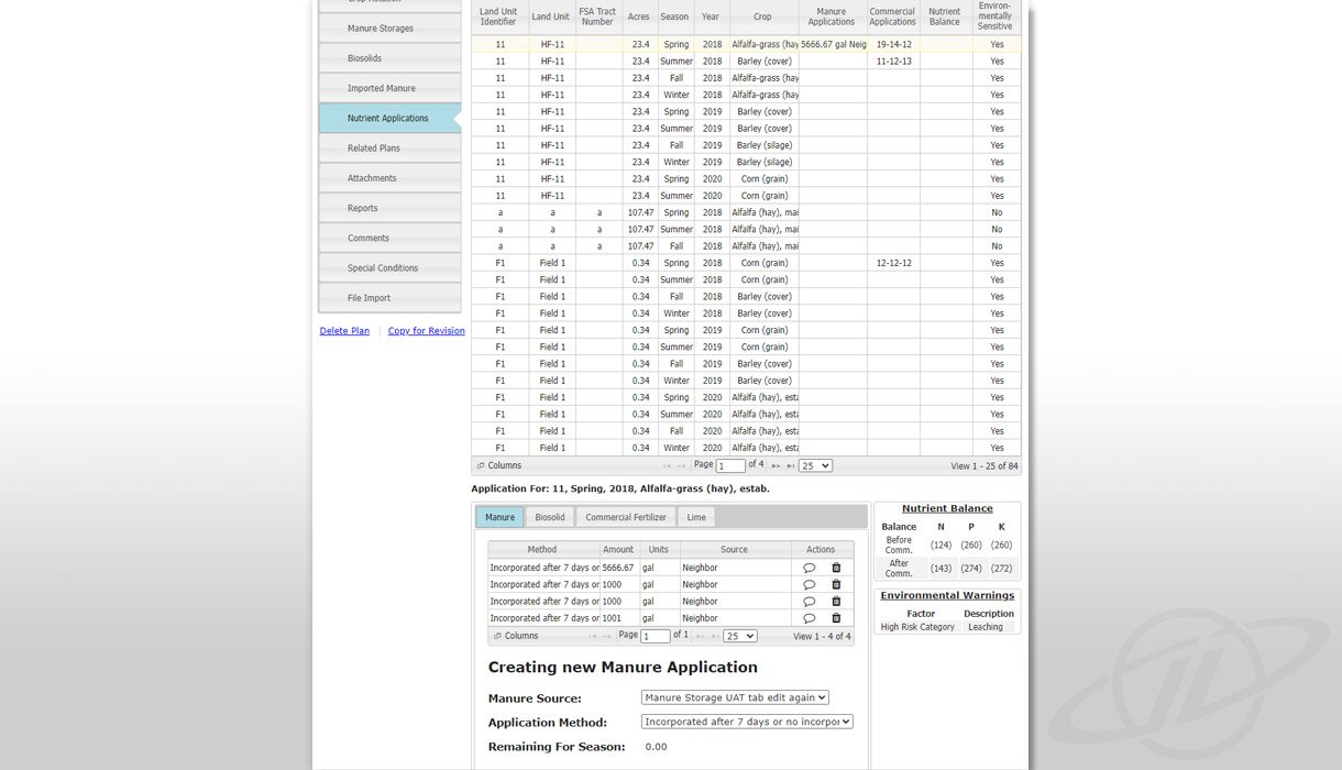
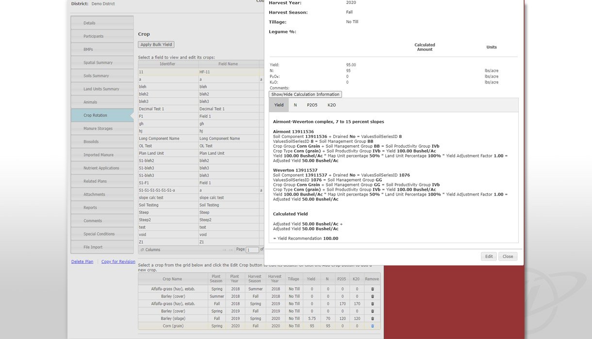
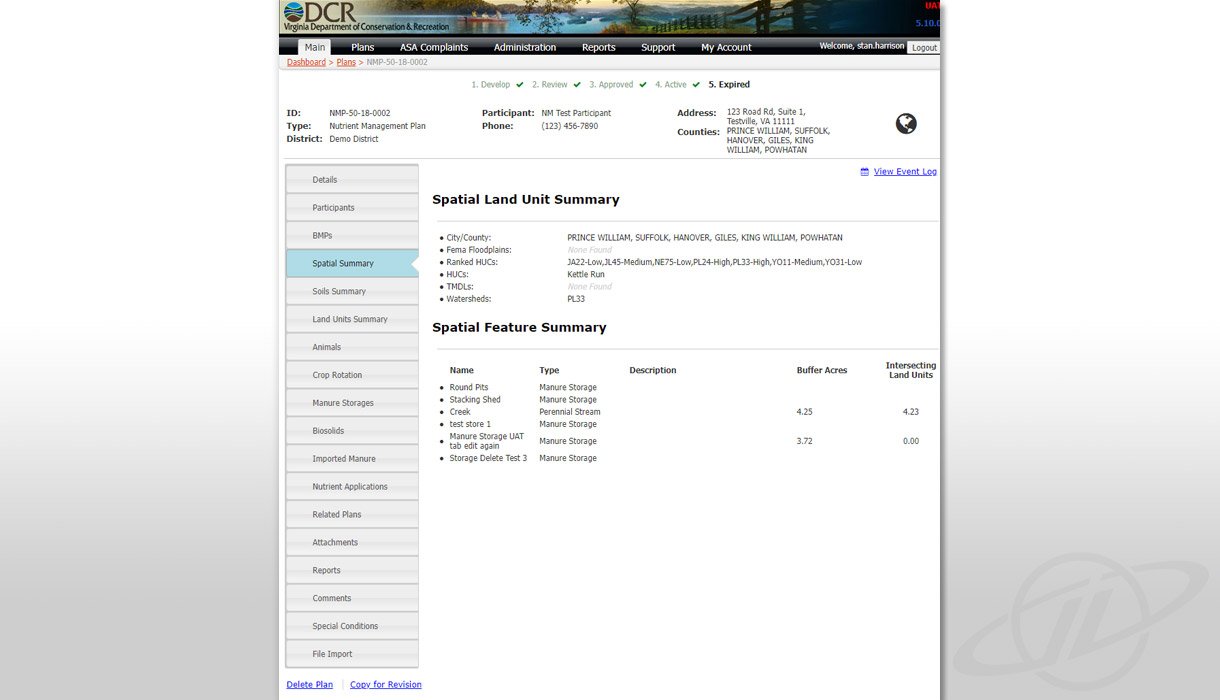
In response to the VA DCR’s challenge, GeoDecisions partnered with VA DCR to introduce the Nutrient Management Planning Module into the Conservation Application Suite (CAS). This geospatial and planning technology solution was designed to improve operations, assist with their stakeholders’ farming needs, and increase planning efficiency, ideally resulting in increased crop yields. This improved technology enabled VA DCR to leverage existing datasets, such as the SSURGO soil layers from the national dataset of soils, and develop visualizations that made soil selection intuitive, automated, and accurate. The Nutrient Management Planning and AgBMP Tracking Module enhancements assisted Virginia’s 47 Soil and Water Conservation Districts with their sustainable agriculture by developing plans, including recommendations to implement BMPs, by protecting and improving water quality.
The greatest improvement to VA DCR’s system was the ability for planners to standardize the soil selection process. In the previous application, data was stagnant because each aspect was manually inputted, meaning updates had to be hard coded as they were not updated automatically. Additionally, field soils were manually selected, increasing the possibility for user error and/or miscalculation or misinterpretation. The previous application did not have mapping capabilities; all mapping was done separately, leading to a longer visualization process. With the AgBMP Tracking Module, all soil selection is done spatially through automation, increasing the planning accuracy, and saving stakeholders time and resources. And, since this process is designed to help the Environmental Protection Agency improve water quality that is affected by harmful soil runoff and promote habitat conservation, the efficiency of this new system has a positive impact on the environment and natural resources conservation.
Although the AgBMP tool was new, the previous system was established in the CAS that already contained modules for tracking Agricultural BMPs and share associated funding costs for creating Conservation and Resource Management Plans. The Nutrient Management Planning Module addition allows nutrient management specialists in VA DCR’s regional offices to provide direct technical assistance to farmers by developing site-specific nutrient management plans, simplifying data collection and reporting to the Chesapeake Bay Program. This new reporting structure allows planners to visually demonstrate progress toward meeting the goals of the Chesapeake Bay Watershed Implementation Plan.
KEY TECHNOLOGY
Built on SQL Database.
Esri WebMap.
Custom Enhancements by GeoDecisions .
KEY TAKEAWAYS
Integrated a Nutrient Management Planning Module with VA DCR’s existing Conservation Application Suite, leading to higher quality data reporting.
Saved time by automating soil selection, evolving away from manual data integration within the Conservation Application Suite.
Developed better data visualizations, allowing VA DCR to improve operational awareness, reduce soil runoff deterrence, and increase overall efficiency.


