
Aerial Survey Maps Custom Solution for South Florida Water Management District
/Client: South Florida Water Management District
Location: West Palm Beach, Fla.
Challenge
The South Florida Water Management District (SFWMD) was looking to expand its mapping solution to collect data when conducting aerial surveys via helicopter. Due to the area's ecology and land features, they cannot use traditional survey equipment. The information collected during these helicopter flights helps data collectors and analysts identify and organize assets, observe South Florida’s ecology, and build geographic information systems (GIS) maps.
Prior to working with GeoDecisions, SFWMD used an obsolete data collection software that the manufacturer no longer supported. To preserve SFWMD’s data collection team’s mission, GeoDecisions replaced the previous software and introduced a new solution that expanded the available features and increased the web mapping functionality.
Solution
GeoDecisions directly supported SFWMD’s monitoring and rapid assessment needs as part of the agency's ecological restoration and flood control missions. We collaborated with the geospatial team for their in-flight (helicopter) data collection to help meet the requirements of the vegetation management data collection project and built an Esri® custom mapping solution.
GeoDecisions introduced new technology by developing an improved solution that enhanced functionality. Keeping the user experience in mind, we used technology relevant to SFWMD that is scalable, flexible, and futureproof. Our solution allows the SFWMD team to control its technology more and manipulate needed data collection points.
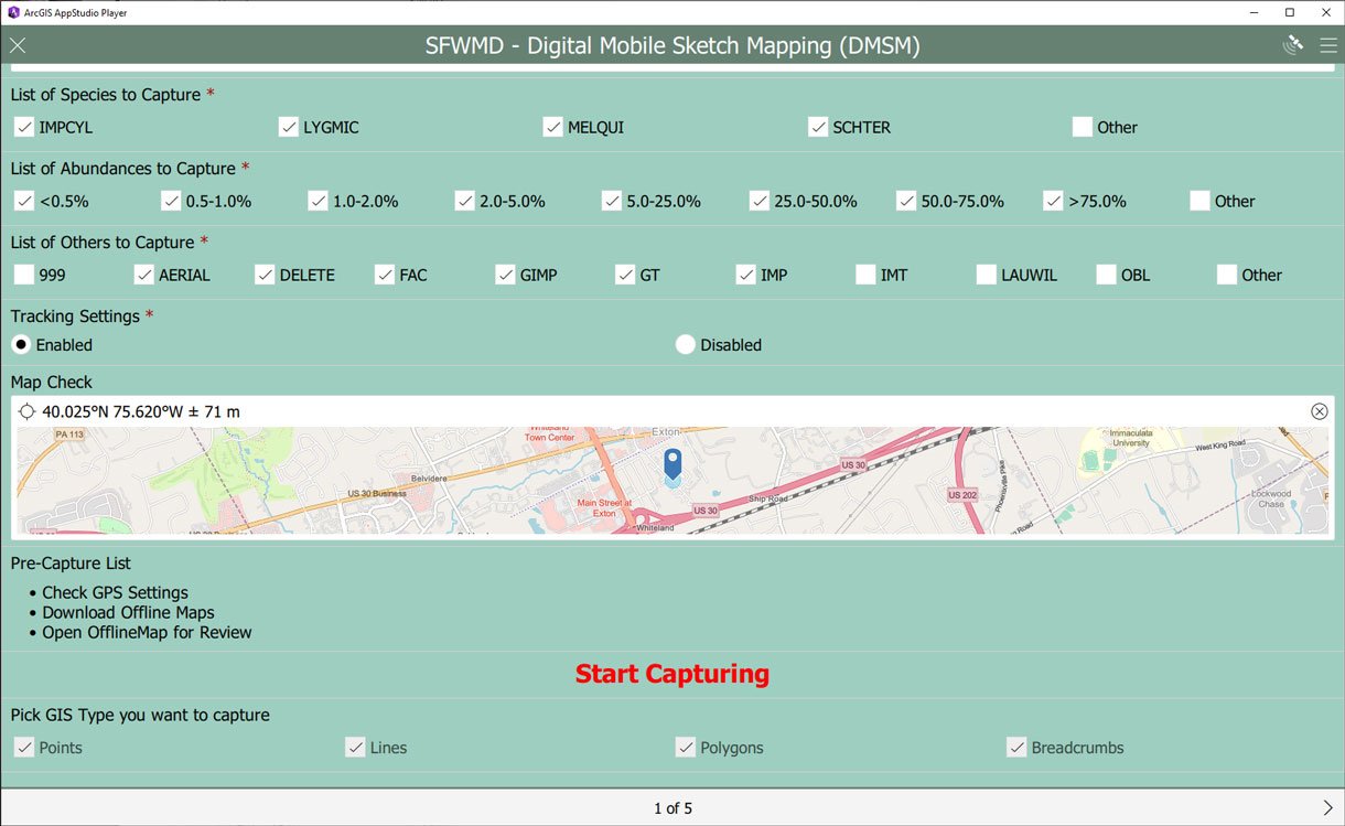
We designed and implemented this new solution using Esri Survey123, Esri AppStudio, and Python scripting technology, which we also used to configure data collection workflows. GeoDecisions’ agile project approach allowed continuous feedback throughout solution design and implementation. After each two-week sprint, SFWMD tested and reviewed the application, provided critical feedback, and ultimately increased overall client satisfaction.
Custom Mapping Features
GeoDecisions integrated numerous features that improved previous functionality with new technological innovations. SFWMD conservation specialists (users) are helicopter passengers as they collect data. The solution features include:
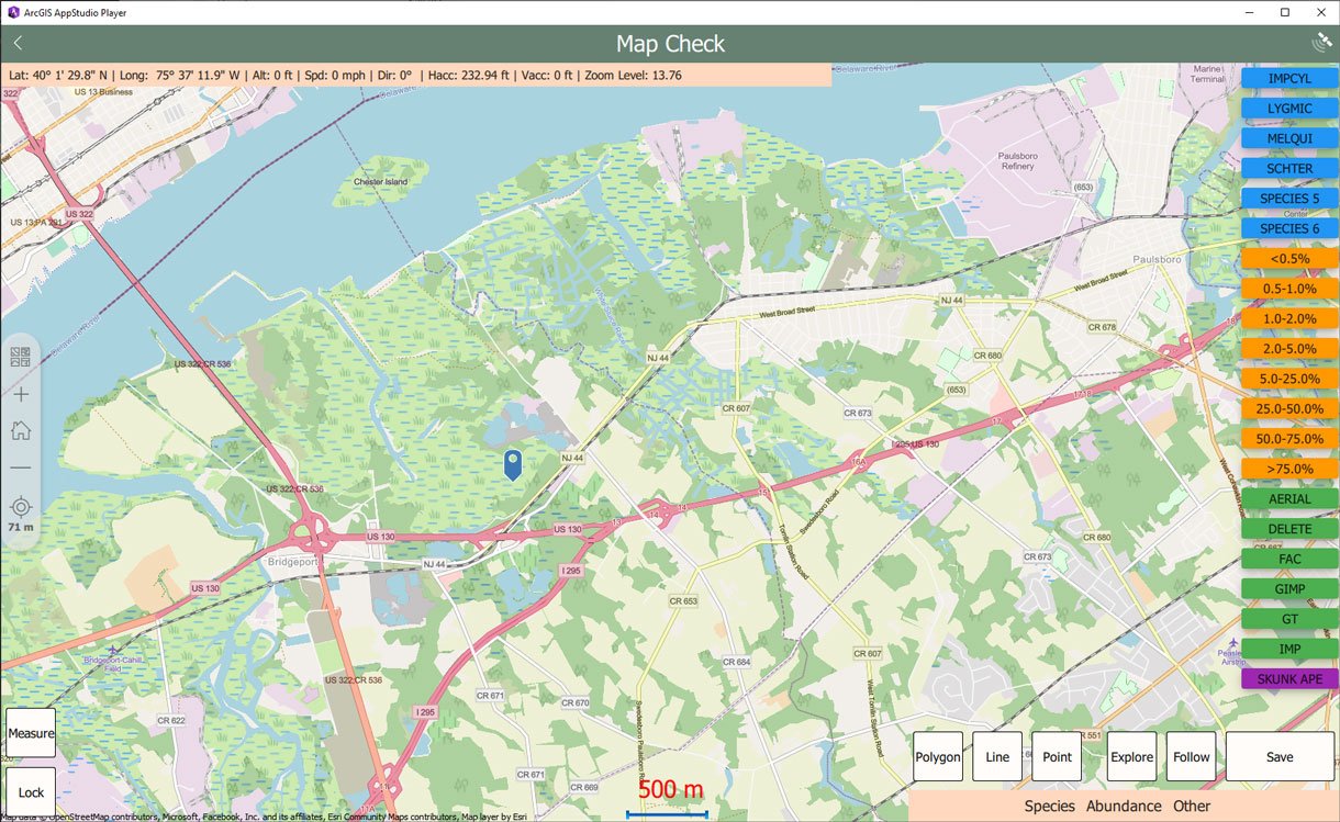
Map Follow Mode: Allows SFWMD to follow the user location during flight and lock the follow position to one of nine quadrants on an interactive map.
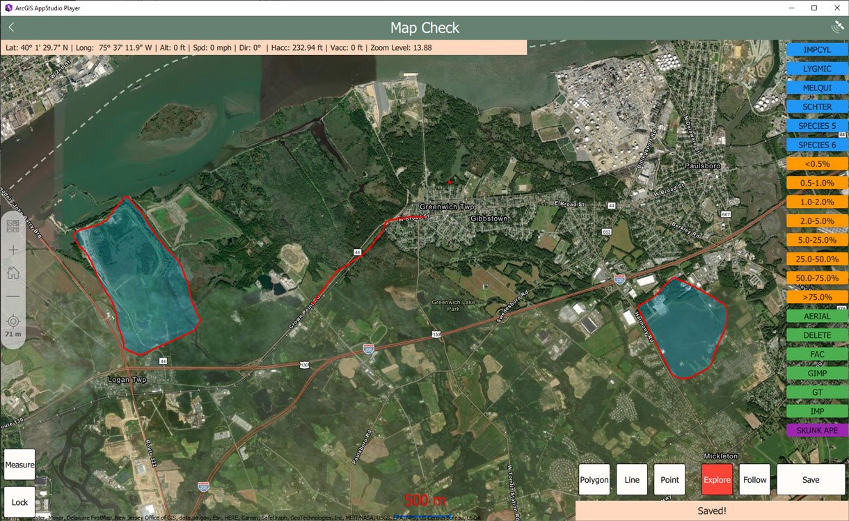
Map Editing Mode: Uses a click-to-draw feature to select any geometry from the hotkeys and draw them on the map.
Map Navigation Mode: Gives the ability to move around the map and view features and imagery, as well as measure GIS attributes such as distances, perimeters, and areas.
Map Area Generation: Creates map areas based on existing web maps. Users can select an area, generate custom maps using Esri ArcGIS Online and Python scripting, and incorporate aerial images.
Workflow Configuration: Uses Survey123 to drive the map component geometry options and feature tagging options.
Scripted Back-End Processes: Accomplishes post-processing using Python scripting.
Optimization for In-Flight Data Capturing and User Experience: Monitors application response during flight.
Track Mode: Uses time intervals to simplify the data during post-processing using a breadcrumb approach. After each flight, they can see where and how they flew along the route.
Emergency Response Functionality
A pleasant byproduct of GeoDecisions’ solution is that SFWMD also has increased emergency response functionality for when natural disasters occur. When Hurricane Ian hit in Sept. 2022, SFWMD was comfortable enough with the data collection tool and its functionality to increase data collection capabilities. They scaled the tool to collect additional data to assess the large-scale hurricane damage. In turn, they also used the data collected to update their inventories and make restoration plans, increasing efficiency and data sharing.
Key Technologies
Esri ArcGIS Online.
Esri Survey123.
Esri AppStudio.
Python scripting technology.
Key Take-Aways
Prioritized the client journey by developing an improved solution that automated previously manual processes, resulting in 50% time savings.
Developed a new data collection approach by reducing the time between initial evaluation and solution editing by five times.
Implemented a scalable and flexible solution that the user can adapt, increasing efficiency.
Delivered a solution prioritizing the user experience for individuals during flight, accounting for flight conditions such as noise, turbulence, and other distractions. The user enhancements include:
Considered right-handed versus left-handed configurations.
Removed unnecessary buttons.
Reduced user fatigue by streamlining the data collection process and decreasing the number of steps from five to two.
Provided a flexible solution that added a layer of data collection capabilities that can be used during an emergency situation.


